| The
Irthlingborough Pocket Park has a history spanning several Millenniums.
The Park and surrounding area of the Nene Valley is rich in sites of
archaeological interest, including Iron Age field systems, and sites of
Celtic and Roman buildings, and roads. More recently the local Iron ore
mines and gravel pits have had a major influence over the area.
Irthlingborough
Historical Society has gathered
information about the site and surrounding area for a number of years.
The information is summarised within this report. The meadow area is the only part of the pocket park which has not been totally altered within the recent past by gravel extraction. This area was known to be rich in early pottery shards and coins. Once the decision to transform this area into a meadow had been taken and subsequently seeded, the society performed a field walk on the site with the advice of the county Archaeological Department. The walk resulted in a wealth of finds, mainly from the Roman period; with the added bonus of a Mesolithic (Mid Stone Age) worked flint tool probably dating back 7000 years (Fig 1 & 2). |
|
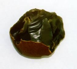
Fig. 1 |
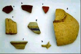
Fig. 2 a
& b). Iron Age pot, c.) Roman Samien Ware, d.) Roman vessel, e.)Roman
Handle, f.) Roman Vessel, g.) Medieval drinking pot, h.)Victorian
tobacco pipe |
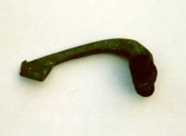
| In
addition to the finds made during the field walk a local metal detector
enthusiast had found a number of 1st and 2nd
century Roman coins and a 2nd century Roman brooch, (Fig.3). |
|
|
Fig. 3 |
The
presence of such a large amount of 1st and 2nd
Century Roman finds supports the likelihood of some form of settlement.
This theory is also supported by the existence of a Roman road through
the centre of the Park. It had been known for a number of years that
Roman Road, No.570 from Lowick to Irchester skirted Crow Hill,
ran through
the town
to the Garden Fields
near Crouch Road; it then split. One route follows the back of the
Nicholas Road gardens and onto Wellingborough. The other route went
diagonally across the field via the south side of the sub station at the
bottom of Tannery Cottages and onto Irchester. During the late 1950's a
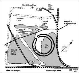
survey team from the local mines were, surveying land in the pocket park
area and came across a limestone layer below the surface where clay and
gravel would be expected. This layer was approximately 3 metres wide. The position of this anomaly corresponds very closely with
the suspected position of the Roman Road and an ancient footpath running
across the area. (fig.4). |
|
In addition to the human history of the site, local gravel extraction
has unearthed a much more distant history to the area. Many fossils have
been uncovered including ammonites and other fossils. These were
deposited in the area at the end of the last ice age, approximately
25,000 years ago. These fossils probably date back to the Jurassic
period (70 million years ago). The recent history of the site has been very much influenced by the industrial age. To the south of the park, the LNWR Northampton to Peterborough railway line was opened in 1845. A branch line was introduced in 1890 to serve the Irthlingborough Iron Ore Companys Quarries and subsequently ‘The Metropolitan Brick and Tile Company’; this later became a tannery.
|
Fig. 4 |
|
Fig. 5 |
|
| A number of bricks from the Metropolitan Works have
been found within the pocket park. This branch line forms the northern and eastern perimeter of the pocket park. A signal
box was also constructed with the opening of the branch line; the
foundations for this can still be found next just before the bridge and
next to the river, (fig. 4). From 1915 the branch line was used by ‘The Ebbw Vale
Steel, Iron, and Coal Company’ for their quarry and later extended to
their iron ore mine which started production in 1918. The mines were
taken over in 1935 by Richard, Thomas and Baldwin. Another branch line
was opened in 1897 to service the cement works in Wellingborough Road.
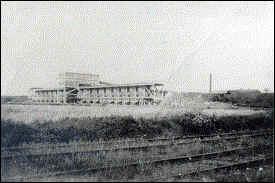
The landscape to the north west was dominated by the iron ore kilns and
Sinter plant, (fig.5).
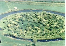
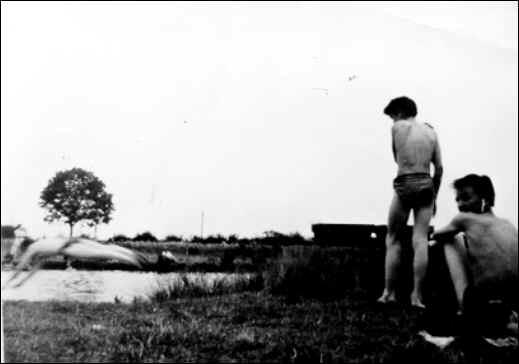
Positioned in the middle of the pocket park was a reservoir used as a
water source for the iron ore processing works. This was known locally as ‘The Res’ or ‘The Ring Res’, due
to its shape (fig.4). It was a
favorite haunt for local kids to cool off in during hot spells (figs.6&7).
Fig. 6 Aerial View of 'The Res' Fig. 7 Cooling Off |
|
|
The mines were closed in 1965, and the land remained unused until the building of the Pinetrees Estate in 1979. Prior
to gravel extraction the land within the boundaries of the pocket park,
consisted of ploughed fields. Gravel
extraction had been underway in the area since the early 1960’s. The
actual pits within the Pocket Park were dug in about 1976. Nature was
then given a chance to further develop the site as a haven for the
wildlife and flora. Hansons helped this process by seeding the meadow
area and planting the surrounding bushes and trees. In
2000 the
whole site
was offered
to Irthlingborough council for the
purchase price of £1.
|
|